Upland & Forests
 Rio Chama Watershed NRCS Report, USDA.
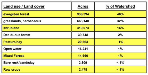
The Rio Chama watershed is nearly half evergreen forest at 46% of the land cover. The Forest Service owns 50% of the watershed, with 944,000 of those 1,007,100 acres falling within Rio Arriba county. The next largest land cover of the watershed is 32% herbaceous grasslands, followed by 16% shrublands and 2% deciduous forests. The uplands ownership and management of the forest are on private lands and tribal lands. The middle and lower section of the watershed has the greatest percentage of USDA Forest Service ownership and management, including surrounding the great area of our study site.
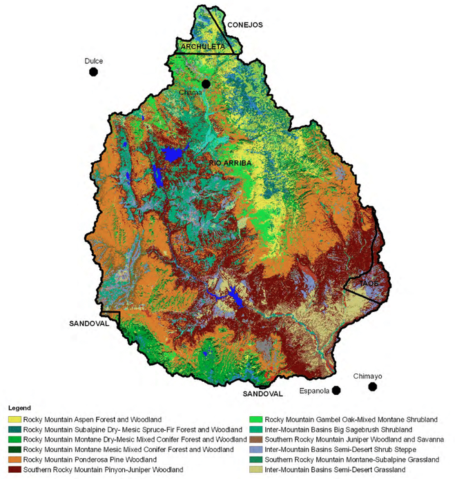
The most prominent ecosystem type is the Rocky Mountain Ponderosa Pine Woodland at 24% of the watershed, followed by the Southern Rocky Mountain Pinyon-Juniper Woodland (SRMPJW) at 21%. The next two ecosystem types are the Inter-Mountain Basins Big Sagebrush Shrubland at 8% and the Inter-Mountain Basins Semi-Desert Grassland (IMBSD) at 5%. The second and fourth most prominent ecosystems, the SRMPJW & IMBSD, are the two most prevalent in our study area.
The most prominent ecosystem type is the Rocky Mountain Ponderosa Pine Woodland at 24% of the watershed, followed by the Southern Rocky Mountain Pinyon-Juniper Woodland (SRMPJW) at 21%. The next two ecosystem types are the Inter-Mountain Basins Big Sagebrush Shrubland at 8% and the Inter-Mountain Basins Semi-Desert Grassland (IMBSD) at 5%. The second and fourth most prominent ecosystems, the SRMPJW & IMBSD, are the two most prevalent in our study area.
Rio Chama Watershed NRCS Report, USDA.
Riparian Vegetation
The vegetation in the Lower Rio Chama is comprised of different types of vegetation. The types of riparian vegetation found are:
The current infrastructure in the Rio Chama cannot withstand more than 1800 cfs. This is not enough to guarantee the wellness of the riparian vegetation along the river. The lower Rio Chama is not flooding because of controlled flows from Abiquiu Dam. If the infrastructure could handle higher flows, and the area was able to flood, the riparian vegetation would be able to reproduce.
Click here for a map of the riparian vegetation in the study area.
Sources:
1. http://southwestpaddler.com/docs/riograndenm14.html
2. A preliminary riparian/wetland vegetation community classification of the Upper and Middle Rio Grande watersheds in New Mexico- Paula Durkin, Esteban Muldavin, Mike Bradley and Stacey E. Carr.
3. U.S. Department of the Interior Bureau of Reclamation Upper Colorado Region Albuquerque Area Office Apendix A: Upper Rio Grande Systems and Operations.
- Cottonwoods
- Coyote Willow
- Russian Olive
- Ponderosa Pine
- Douglas Fir
- Pinyon Pine
- Juniper
- Mountain Mahogany
- Currant
- Oakbrush
- Serviceberry
The current infrastructure in the Rio Chama cannot withstand more than 1800 cfs. This is not enough to guarantee the wellness of the riparian vegetation along the river. The lower Rio Chama is not flooding because of controlled flows from Abiquiu Dam. If the infrastructure could handle higher flows, and the area was able to flood, the riparian vegetation would be able to reproduce.
Click here for a map of the riparian vegetation in the study area.
Sources:
1. http://southwestpaddler.com/docs/riograndenm14.html
2. A preliminary riparian/wetland vegetation community classification of the Upper and Middle Rio Grande watersheds in New Mexico- Paula Durkin, Esteban Muldavin, Mike Bradley and Stacey E. Carr.
3. U.S. Department of the Interior Bureau of Reclamation Upper Colorado Region Albuquerque Area Office Apendix A: Upper Rio Grande Systems and Operations.